In January and February, Marin County gets plenty of rain. When the sky clears, hills are bright green, water bubbles down creeks lined with ferns and moss-covered rocks, and waterfalls are flowing.
It’s time to go out on a family hike.
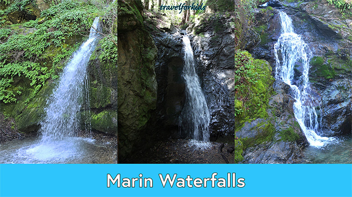
Here’s three favorite waterfalls:
Buck Gulch Falls Trail – Novato
Cascade Falls – Mill Valley
Cascade Falls – Fairfax
Tips – Plan ahead
Bring water or drinks.
Wear waterproof shoes or rain boots.
No restrooms, pack out any trash.
When water is rushing and high, do not wade in, or go across the creeks.
Be respectful of private property when parking along residential roads.
Weekends trails are more crowded, and parking is limited.
![]()
Buck Gulch Falls Trail – Novato
Ignacio Valley Open Space Preserve
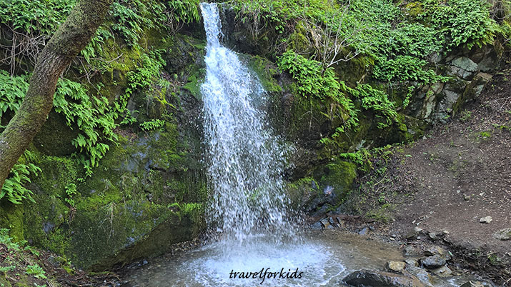
Buck Gulch Falls is one of our favorite hikes, perfect for everyone in the family, including grandparents.
Hike is about one and half miles round trip, on a largely level trail.
Buck Gulch Falls Trail begins at Fairway Drive, pavement soon turns into an easy level dirt trail.
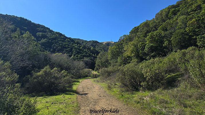
Trail meanders along the creek, through the woods, just follow the signs for the Buck Gulch Falls Trail. Stay on the trail, this is a public easement through private property.
At the end of the trail, the waterfall cascades into a wide, shallow pool. Return on the same trail the way you came.
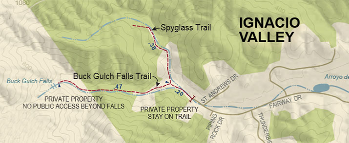
Here’s a detailed map and more info about Ignacio Valley Open Space Preserve.
Directions – Exit HWY 101 at Ignacio Blvd. Drive up Ignacio Blvd. exit onto Fairway Drive. Drive through residential district to the Buck Gulch Falls Trail. Park along the road, this is private property.
![]()
Cascade Falls – Mill Valley
Walk to a waterfall flowing over the rocks into Cascade Creek, surrounded by redwoods.
Hike to the falls starts from Old Mill Park in downtown Mill Valley.
Short walk –
From Old Mill Park, drive up Cascade Dr. until you come to a small parking lot for the Falls. There is also some car parking available along Cascade Dr. above and below the parking lot.
It’s just an easy walk along the wide trail, at the bridge go right across the creek, you’ll see the falls ahead. Trail is wide enough for stroller, easy walk for toddlers.
Longer hike – 2 miles round trip
Start at Old Mill Park, walk up Cascade Dr., lined with redwoods and houses on either side, paved road follows the creek. It’s okay to walk on the road.
About half mile up Cascade Dr. on the left, look for sign on a tree – 131 (Mill Valley Steps Lanes Paths). Dirt trail begins here.
Follow the trail, as it winds around the creek, climbing up a rocky section to three pools with ferns on the banks. Continue on the trail, as it goes back and forth over the creek with two bridges, until this trail ends at road, and car parking lot for Cascade Falls.
Tip: Trail along creek is quite scenic, but narrow in sections, there are no railings.
From Cascade Falls, to return to Old Mill Park, walk back down on Cascade Dr., where you started.
Directions – To start the hike, find parking close to Old Mill Park in downtown Mill Valley. Old Mill Park has restrooms, picnic tables and trash cans. Four hour parking is available on town streets.
![]()
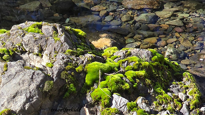
Cascade Falls – Fairfax
Cascade Canyon Open Space Preserve
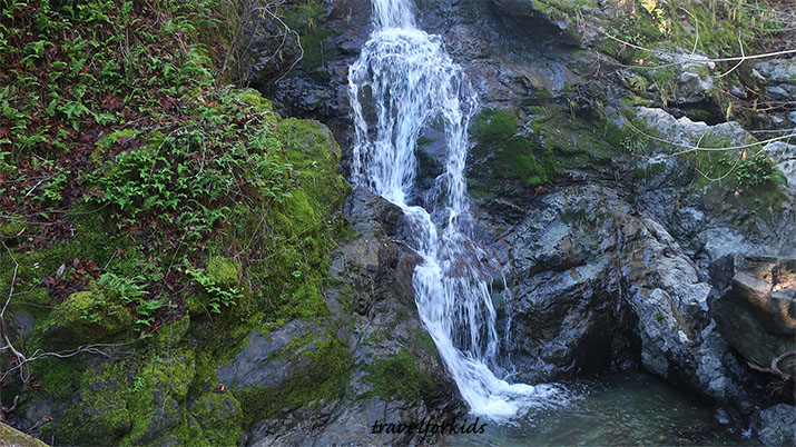
Cascade Falls is 20 feet high, the creeks run year round but waterfall is best in winter months.
Start at end of Cascade Dr. which ends at a wooden gate, start walking up the dirt trail.
You’ll come to the Welcome sign with a map. Continue along the trail, until you come to a fork.
High Water Trail goes off to the right. To the left is the creek. During low water, you could choose to wade through the creek and pick up Canyon Trail which goes up the west side.
Tip: Take the High Water Trail when creek is rushing too fast to wade safely. However, High Water Trail is a narrow trail, there are no hand rails, couple of spots where you climb over rocks, need to watch your step.
Both trails go to Cascade Falls. Part of the trail is labeled Cascade Fire Road. At the bridge, trail goes over the creek, then it’s a quarter mile walking along the creek to Cascade Falls.
Canyon Trail on the west side of the creek is more level, but requires wading across the stream in couple of places to follow the trail.
When we hiked to Cascade Falls, we took the High Water Trail to the falls and returned on the Canyon Trail, crossing back the creek to finish where we started.
Tip: This hike is about a mile and half each way. Best spot for picnic is at the bridge, not at the falls.
If you have toddlers along and water is low, they’ll have fun playing in the creek at ford crossings along the trail.
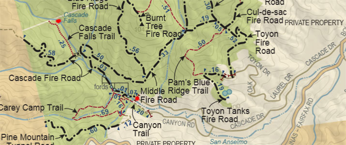
Find a detailed map and more info about Cascade Canyon Preserve.
Directions – From Hwy 101 in Larkspur, take the exit for Sir Francis Drake Blvd west to Fairfax.
Turn left onto Pacheco Ave, turn right onto Broadway and make first left onto Bolinas Rd, right onto Cascade Dr. (at the stop sign) continue about 1.5 miles to the wooden gate (dead end).
Park along Cascade Dr., available parking can fill up early in the day, especially on weekends.
If there’s no parking on Cascade Dr., park on Canyon Blvd. for a slightly longer walk to the trailhead.
Marin County is across the Golden Gate Bridge from San Francisco – a perfect day trip if you’re staying in the city.
Tip: Waterfalls in Marin are seasonal, and turn to a trickle by mid-summer, smaller creeks dry up.
Travel for Kids
Created by people, not AI