Hiking California is part of our family for multi-generations, and thanks to conservation efforts, awesome landscapes, with soaring redwoods, rushing waterfalls, panoramic coastlines, volcanic wonders, glories of the “range of light,” are preserved for the future.
Since we were kids, then with our own boys, we have hiked, camped and backpacked throughout the state, from Anza Borrego to the Redwood Coast.
Here’s five of our favorite summer hikes with kids in California.
These hikes are accessible for younger kids, but also included are suggestions for longer hikes for older kids and teens.
![]()
Tuolumne Meadows – Yosemite
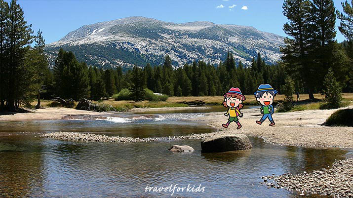
Tuolumne Meadows in Yosemite National Park is alpine “high country,” with mossy green meadows, bubbling streams and sparkling rivers, surrounded by rugged mountains, but is very accessible for kids.
Tip: In summer Tuolumne Meadows may require a day use reservation. Check Yosemite NPS.GOV website.
Another advantage, meadows covers wide area, and trails are less constrained, so even with summer crowds, there’s lots of room to spread out.
Two hikes shown the video are Lyell Fork, and Pothole Dome.
Lyell Fork, Tuolumne River
From the Dog Lake parking lot, follow take the trail (Pacific Coast Trail and John Muir Trail) to the Lyell Fork of the Tuolumne River.
At the bridge are wonderful shallow rock pools and sandy beaches where kids can play, while the panorama of the surrounding mountains is just glorious.
The trail continues along the river – follow it as long as you like. Bring a picnic and spend the day.
Tip: Bring your picnic lunch, Tuolumne Meadows Grill doesn’t seem to be open this summer.
Pothole Dome
You can see Pothole Dome from Tioga Road (Hwy 120), poking up at the western edge of Tuolumne Meadows.
From the parking area, follow the trail that goes around to the eastern side of the dome. From there, climb up the gentle rock slope to the top (200 ft.).
Sitting on a big boulder on Pohole Dome, kids will have a bird’s eye view all around – the meadows to the east, high mountains to the north and another rock dome, Fairview Dome, right across the way.
Elizabeth Lake Trail
With older kids, take a hike to Elizabeth Lake, the trail winds up through a shady pine forest, goes along green meadows next to a sparkling creek, arriving at a spectacular lake, nestled at the base of Unicorn Peak.
Kids will want to explore the paths around the lake, and may even find a little snow at the eastern shore.
The hike is 4.6 miles round trip, the trail begins at Tuolumne Meadows Campground.
![]()
Tomales Point – Point Reyes
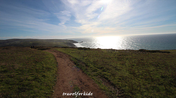
The Tomales Point Trail goes to northern end of Point Reyes National Seashore, this area is a magnificent peninsula with views of open ocean beaches to the west (listen to waves crashing), and views of Tomales Bay and Hog Island to the east.
Take the road to Pierce Point Ranch, parking is available, then follow the trail going north.
The trail goes through the Tule Elk Reserve, and you’re likely to see these majestic animals, native to California. The two best places to spot the herds are White Gulch, and a pond about 45 min. north. Bring binoculars.
Just hike down the trail as far as kids want to go, at 2.5 miles is the highest point, and fabulous views in all directions.
Teens will enjoy hiking to end of Tomales Point, 4.7 miles out, 9.5 miles round trip.
Tip: Stay on the Tomales Point Trail. Tule elk can be grazing close by the trail, do not wander off for a closer view. This is an exposed ridge, and can be windy, and foggy in summer if weather changes, bring a jacket.
![]()
Rainbow Falls – Reds Meadow Valley
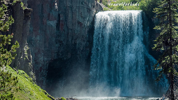
Both our guys agree that Rainbow Falls was the best hike when they were kids.
Also, in summers grandparents, aunts and uncles, cousins, and friends joined our family in Reds Meadow Valley and Eastern Sierra.
Rainbow Falls
From the Reds Meadow General Store and ranger station, pick up the Rainbow Falls trail. It’s a wide, easy trail, little over 1.25 mile each way.
When you get Rainbow Falls, it’s impressive – the Middle Fork of the San Joaquin River plunges 101 ft. down over a volcanic rock cliff, making rainbows as it goes.
At the bottom of the falls, the water is shallow, and kids can wade and skip rocks for hours. (Swimsuits are a plus when the kids get wet).
Red Cones Trail
For a longer hike, for older kids and teens, this is a stellar hike. From the Reds Meadow General Store, follow the Mammoth Pass trail for 1.25 miles. Continue straight to the top of the Red Cone, a huge rusty-red cinder pile, with great views in all directions.
From Reds Meadow it’s 6.5 miles round trip, with some up and down (1000 ft elevation gain), but even younger kid can do it, if you spend all day.
Agnew Meadows
![]()
Bumpass Hell – Lassen
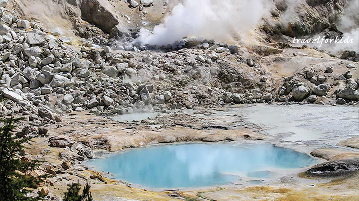
In Lassen Volcanic National Park, Bumpass Hell with its mud pots, fumaroles and boiling springs is a “must see ”
Tip: Due to heavy snowfall this winter, Bumpass Hell trail is currently closed won’t open until July, at the earliest.
Check the Lassen National Park website for trail updates.
The trail is largely level, goes around the side of the mountain, then drops down. You can smell and hear loud hissing sounds and stinky egg smells. Fumaroles steam like dragons breathing out of the earth, boiling springs ooze with sulfuric acid and iron pyrite, mud pots slurp and burp.
The trail to Bumpass Hell is 3.0 miles round trip, even little kids can manage the trail. Stay on the trail and boardwalk, don’t let the kids wander off.
Wondering about the name? Mr. Bumpass, an early explorer, was severely burned when he accidentally stepped through a fragile crust.
Tip: The trail is dusty and rocky, so wear closed-toed shoes (don’t hike in flip-flops) and bring drinking water.
![]()
Fern Canyon – Redwood Coast
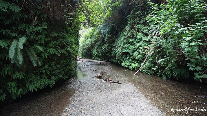
Fern Canyon is located in Prairie Creek Redwoods State Park, on the Redwood Coast (includes both Redwoods National and State Parks).
From the parking lot, it’s just a short walk to the opening of the canyon, covered with walls of five-finger ferns, glittering mini-waterfalls cascading off mossy green cliffs, a creek flowing through the sandy bottom of the canyon.
Walk up the canyon as far as kids feel like exploring. The canyon is just spectacular, and if it feels like a setting for Jurassic dinosaurs, it was used as a location in “The Lost World” movie.
Tip: Best to wear water shoes, so kids can wade in the creek in low water season during the summer.
Fern Canyon Loop Trail –
For a longer hike with older kids, at the entrance to Fern Canyon, take a left and go up the James Irvine Trail, which follows above the canyon. At .5 mile, turn right onto the Fern Canyon trail, and follow the stairs down into the canyon, then hike out to the parking lot through the creek.
To reach Fern Canyon, it’s over ten miles off Hwy 101, including seven miles down a gravel dirt road with stream crossings, but well worth visiting. From Hwy 101, take Davison Rd, which turns into Gold Bluffs Beach Rd., drive to the end of the gravel dirt road to the parking lot.
Tip: In summer, Fern Canyon is very popular, and there are limited number of parking spots for the hike – go early the day.
![]()
Tips hiking this summer
- Do not hike in California deserts – Joshua Tree, Death Valley, Mojave National Preserve. Summer temperatures are just too hot, over 100 degrees. Even on a short hike, it’s easy to get dehydrated and disoriented.
- Fire danger is very high in summer. Campfires will be restricted, and where allowed, never leave open flames unattended. Do not set off fireworks, even sparklers, dry grassy areas can easily catch fire!
- Coastal headlands – Along the northern California coast, Big Sur to Crescent City, coastal headlands are often cloaked in summer fog. Also, it might be sunny one moment, then fog rolls in, panoramic vistas are obscured, and it’s chilly.
- For hikes inside national parks, check on NPS.GOV for alerts about temporary closures, and WEATHER.GOV for red flag (fire danger) warnings.
- For more tips, read our blog post: “Travel tips: California Hiking with Kids”
On Travel for Kids, find more hikes and fun things to do with kids in California.
Travel for Kids
Created by people, not AI